UC Geologists Interpret Monsters, Meteors, Global Extinctions and Historic Bricks
The Department of Geology in the University of Cincinnatis McMicken College of Arts & Sciences is a nationally ranked program with high-caliber faculty and a strong research reputation. The departments strength is based on teaching and research in many areas of the geosciences including paleontology (
a program ranked 6th in the nation
), Quaternary geology, geomorphology, sedimentology, stratigraphy, tectonics, environmental geology, and biogeochemistry. That varied array of interests will be on display at the annual meeting of the Geological Society of America in Denver.
Among the University of Cincinnati presentations at the Oct. 27-30 meeting will be:
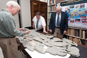
Ordovician Monster Debuts On A National Stage
Around 450 million years ago, shallow seas covered the Cincinnati region and harbored one very large and
. Despite its size, no one has ever found a fossil of this monster until its discovery by an amateur paleontologist last year. The fossilized specimen, a roughly elliptical shape with multiple lobes, totaling almost seven feet in length, has been discussed at regional scientific meetings. A variety of noted paleontologists have visited the University of Cincinnati to examine the specimen, known as
. At the national Geological Society of America annual meeting, amateur paleontologist Ron Fine of Dayton, Ohio, who originally found the specimen, Carlton E. Brett and David L. Meyer of the University of Cincinnati geology department, and Benjamin Dattilo of the Indiana University Purdue University Fort Wayne geosciences faculty, will invite insight from a nationwide audience in a continuing effort to understand this previously unknown creature.
Meteorite Crater Yields Information On Paleozoic Environments

Warren Huff
The Siljan Impact Structure in central Sweden is a meteorite crater, the largest known impact structure in Europe. The impact that created the structure, 377 million years ago during the Devonian period, deformed and exposed older rock layers from the Ordovician and Silurian periods. UC geology professor Warren Huff, working with German geologists Oliver Lehnert of Erlangen University and Guido Meinhold of the University of Goettingen, have analyzed core samples containing ash layers deposited from Paleozoic volcanoes. Their analysis provides new possibilities for reconstructing early Paleozoic marine environments and climate in what is now northern Europe.
Huff has been elected a GSA Fellow and will be recognized at this meeting.
Sizzling Oceans Follow Great Dying
Around 250 million years ago, at the end of the Permian period, Earth almost became a lifeless planet as 90 percent of all living species disappeared in what scientists have called The Great Dying. UC geology professor Thomas J. Algeo has spent much of the past decade investigating the chemical evidence preserved in rocks formed throughout this major extinction and afterward as life gradually adapted to a changed environment. Much of the geologic evidence ended up being washed into the ocean, and that is where Algeo and his colleagues look for it. Oceanic deposits from China demonstrate strong warming in the post-extinction ocean. Algeo and colleagues from several Chinese institutions will present the latest efforts to reconstruct these extreme conditions at the annual meeting of the Geological Society of America.
Species Survival Rates Are Independent of Genus

Arnold Miller
As the Paleobiology Database, an online resource for information on the distribution and classification of fossil animals, plants and microorganisms, is populated with more data, scientists can ask more refined questions about ancient life. Arnold Miller of the University of Cincinnati and Michael Foote of the University of Chicago demonstrate how more data and finer detail contribute to deeper understanding of the relationship between marine (sea-dwelling) genera and their constituent species in a presentation to the Geological Society of America. Miller and Foote analyzed organisms at the genus level and at the species level through several mass extinctions over geologic time. They discovered that, while mass extinctions affect the long-term persistence of organisms at the species level as well as at the genus level, the species with the best persistence do not necessarily belong to the genera with the best persistence. Long-term evolutionary behavior of species is therefore not necessarily a predictor of what we observe for their corresponding genera. In other words, the whole does not always reflect the parts.
The Geology of Cincinnatis Historic Building Boom: What Makes A Good Brick?
Between 1810 and 1860, the population of Cincinnati mushroomed from 2,500 to more than 160,000. An undergraduate class project at the University of Cincinnati is now a national presentation at a major scientific meeting and shows how good clay for good bricks helped support this boom. UC geology professors Warren Huff and Barry Maynard led a group of students in an examination of Cincinnatis historic bricks. The best bricks, they discovered, were made from clays deposited in glacial lakes. This clay was found in abundance in the citys West End and Brighton neighborhoods, both of which were home to many brickyards. A detailed chemical analysis separates this good clay from inferior stream-deposited clays.
Long-Gone Glaciers Help Understand Andean Climate

Dylan Ward
The subtropical Andes are currently among the driest regions on Earth. While the causes of the overall arid climate are understood, more research is necessary to achieve a detailed understanding of the areas climate history. UC geology assistant professor Dylan Ward, working with Joseph Galewsky of the University of New Mexico, took a closer look at evidence that the Chilean Altiplano was significantly wetter during the last ice age. Ward and Galewsky conducted the first systematic effort to date ancient glacial deposits in the area. Their results suggest that changes in the Earths orbit and consequent changes in summer sunlight, by changing the location or intensity of summer monsoons, may have been responsible for bringing in enough moisture to glaciate the region.
Iron Minerals Influence Lead In Drinking Water
Poisonous lead, entering drinking water from sources such as lead pipes, solder and brass plumbing, remains a risk to human health. Scientists have traced high concentrations of lead to the corrosion scale that builds up in galvanized iron pipes in premise (or household) plumbing, but the chemistry of these interactions isnt well understood. Student Lauren Wasserstrom, working with UC geology professor Barry Maynard, simulated corrosion scales with a variety of iron minerals and measured the ability of these minerals to take up lead from water. The minerals differed significantly in their ability to take up lead. The researchers also discovered that the different minerals reacted differently to other water-carried metals such as copper and zinc.
Abrupt Climate Change In An Ancient Sea
In general, the limestones known as the Lexington Formation in central Kentucky were deposited in the cool waters of a shallow sea. The absence of corals and sponges and the presence of phosphate grains indicate cool conditions around 452 million years ago. New highway construction near Winchester, Ky., has exposed a layer in the middle of the Lexington Formation that preserves a very different climate. Rich in the fossil remains of sponges, coral and algae, this interval suggests a previously unrecognized period perhaps 500,000 years in duration of abrupt warming which permitted the proliferation of organisms otherwise rare or absent from that ancient sea. A description of this new exposure will be presented by UC geology professor Carlton Brett and two students, Allison Young and Alex Reis.
Making Sense of Geologic Aliases
The problem, according to UC graduate student Thomas Malgieri, stems from too many names. The fossil-rich rocks of central and northern Kentucky are well known, but individual exposures have been named haphazardly, based on the fossils they contain, or the depth of the water in which they were formed, or their locality. Working with UC geology professor Carlton Brett and fellow students James Thomka and Christopher Aucoin, Malgieri identifies key stratigraphic surfaces to correlate units independent of accepted labels to gain a better understanding of the geologic record. This method highlights the unconformities or missing stratigraphic layers caused by erosion or falling sea levels which have been previously overlooked.
How Did The Last Ice Age End?
For 2.5 million years, massive glaciers covered almost all of modern Canada and the northern United States and then, just 11,000 years ago, the glaciers vanished. The landscape bears evidence of the former ice sheets in piles of debris left behind. Mapping these glacial deposits offers clues to how the ice advanced and how it went away. Student Kent Walters, working with UC geology professor Thomas Lowell, mapped the glacial deposits of Michigans Upper Peninsula, connecting deposits there to previously mapped deposits in Wisconsin. Walters mapped the deposits in time as well as space by recording new radiocarbon data. The research suggests that the glacier here melted in place rather than retreating northward.
Where Did Sea Scorpions Live?
Eurypterids, often called sea scorpions, are an extinct group of animals related to horseshoe crabs and scorpions. The largest specimens of these ancient predators are more than eight feet long, but most were less than a foot in length. Their remains are often found in layers of rock deposited in highly salty conditions. Did eurypterids actually live in salty conditions? Thats the question asked by UC graduate student Matthew Vrazo. Perhaps, since eurypterids like horseshoe crabs shed their exoskeletons, the fossils are only lightweight molts and not carcasses and may have been washed in from less salty conditions. Working with UC geology faculty Carlton Brett and Brenda Hunda of the Cincinnati Museum of Natural History and Science, Vrazo explored a mathematical solution called semi-landmark analysis. Using precise measurements of the shape and size of fossil specimens, this method can determine whether animals show signs of stunting or dwarfism that might result from life in the stressed environment of highly salty water.
Fading Glaciers Lessen Valley Flood Risk
A very long time ago, the Rishi Valley in northern India suffered a catastrophic flood. The valley still has some glaciers and was once fully glaciated. The valley and a village named Karzok also lie within the current path of monsoon weather. Students Cameron Schwalbach, Jeanette Arkle, Rachel Thomas and Jacob Dillingham, working with UC associate geology professor Craig Dietsch, surveyed the valley to determine, from geologic evidence, whether another catastrophic flood was likely. They found evidence that the ancient flood was caused by melting glaciers, was truly monumental and left extensive evidence of its power. Today, however, with remaining glaciers much reduced in size, it is unlikely that glacially induced flooding is a significant risk. Monsoon and cloudburst flooding may be another matter.
A Guide To The Mother Lode For Cincinnati Fossils
The Cincinnati region is world famous for the abundance and quality of its Ordovician (450 million-year-old) fossils. Scattered throughout the Cincinnati region are layers of soft shale in which fossils are especially abundant and well preserved, known locally as butter shales. Graduate student Christopher Aucoin, along with UC geology professor Carlton Brett and graduate students James Thomka and Thomas Malgieri, conducted a thorough survey of Cincinnatis butter shales, noting that most of them were formed during times of rapid sedimentation that favored mobile organisms over those that anchored themselves to the sea bottom. Such an environment, subject to storms and submarine mudflows, often rapidly smothered the ancient sea creatures, preserving them in outstanding detail.
Can Geologists Promote Citizen Science?
Geology impacts human health and the quality of life in a variety of ways, including groundwater, landslides, mining impacts and land use. Graduate student Julia Linnaea Wise, working with UC assistant geology professor Aaron Diefendorf and Lisa Vaughn of UCs College of Medicine, used evaluation tools common to public health research, such as Group Level Assessments, to identify and rank earth science questions and problems among a broad spectrum of residents in the Cincinnati area. The process helps to position community members as stakeholders in the scientific process, Wise said, and may help identify previously unrecognized concerns while improving communication between scientists and the community.
What Have Humans Done To Island Geochemistry?
The mollusks of the Virgin Islands leave more than pretty seashells to decorate the beaches. They also leave clues to human activity on the islands. UC graduate student Kelsey Feser, working with UC geology professor Arnold Miller and student Spencer Fogelman, sampled mollusk assemblages at seven locations around the island of St. Croix. Detailed analysis of the marine animals, the environment in which they live, and the chemistry of the surrounding sediments revealed clear differences among the sample localities particularly between those on the north shore of the island and those on the south shore. Chemical signatures suggest that human activity may strongly influence the geochemistry, and thus the mollusk communities, of these environments.
Buried Quickly, But Not Buried Alive
For paleontologists, lagerstätten, or Konservat-Lagerstätten (German for preservation reservoir) are mother lodes of beautifully preserved and abundant fossils. UC graduate student James Thomka, working with two amateur paleontologists Thomas Bantel and Donald Bissett as well as UC geology professor Carlton Brett and student Allison Young, explored a lagerstätte in southeastern Indiana with outstanding specimens of fossils known as cystoids. It is often assumed that such abundant fossils in pristine condition must represent live burial from a storm, landslide or some similar mechanism. Thomka and colleagues, however, found evidence for a more complex post-mortem history for these echinoderms including post-burial exposure, overturning, encrustation, and differing amounts of decay. This suggests that these specimens were buried temporarily, then infilled with sediment which got cemented, and then exposed and subjected to a number of processes, before being buried again - either permanently or prior to another episode of temporary exposure.
Seashells Are Armor, But Predators Are Resourceful
Connoisseurs have enjoyed clams for ages and so have sea snails. Many edible clams belong to the family of molluscs known as venerids or Venus clams. UC graduate student Gary Motz studied the shells of venerid clams from the Indo-Pacific region, collecting detailed measurements of shell shape and ornamentation. Much of the ornamentation appreciated by sea shell collectors evolved as protection from various predators. He also recorded which shells showed signs of attack by predatory moon snails. An analysis of the data indicates that variation in shape and form occur through time and across broad geographic areas, but that predators show a distinct preference for particular shapes.
Ancient Swedish Extinction Related To Global Sea-Level Changes
The Ireviken Event is a minor extinction event that occurred around 433 million years ago. Evidence for this short-lived die-off of marine life is well recorded in the rocks of Gotland, an island in the Swedish Baltic Sea. Stratigraphic evidence there records rising and falling sea levels associated with major reef building. UC geology professor Carlton Brett, along with Patrick McLaughlin of the Wisconsin Geological and Natural History Survey and Paul Emsbo of the U.S. Geological Survey, have shown that sea level changes in Scandinavia match well with strata of similar age in Michigan and Appalachia in the United States. The rock and reef layers correlate so well that they reveal a series of abrupt changes in global sea level.
Related Stories
WLWT: Tips to fight off bad allergy symptoms
April 18, 2024
The University of Cincinnati's Ahmad Sedaghat spoke with WLWT about how Cincinnati's geography tends to make allergy symptoms worse and tips to fight off those symptoms.
Medscape: Skin adverse events rare after immunotherapy to treat...
April 17, 2024
Medscape highlighted University of Cincinnati research published in JAMA Dermatology that found skin adverse events were rare following immunotherapy treatments for certain skin cancers.
UC researchers develop new CPAP device
April 17, 2024
Researchers at the University of Cincinnati are developing a VortexPAP machine that takes advantage of vortex airflow technology. A preliminary clinical study with current CPAP users demonstrated that the VortexPAP can deliver the pressure levels that are used in the subjects’ CPAP therapy, but the mask is more comfortable to wear. It has a minimalistic design that is less intrusive and barely touches the patient’s face.