UC researchers find ancient Maya farms in Mexican wetlands
University of Cincinnati archaeologists say these farms likely produced cotton and other goods to support Yucatan trade routes

Archaeologists with the University of Cincinnati used the latest technology to find evidence suggesting ancient Maya people grew surplus crops to support an active trade with neighbors up and down the Yucatan Peninsula.
They will present their findings at the annual American Association of Geographers conference in Washington, D.C.
The Mayan civilization stretched across portions of Mesoamerica, a region spanning Mexico and Central America. The oldest evidence of Maya civilization dates back to 1800 B.C., but most cities flourished between 250 and 900 A.D. By the time Spanish ships arrived in the 1500s, some of the biggest cities were deserted. Researchers at UC are trying to piece together the life history of the Maya before the Spanish conquest.
Nicholas Dunning, a professor of geography in UC’s McMicken College of Arts and Sciences, was part of a research team that found evidence of cultivation along irregular-shaped fields in Mexico that followed the paths of canals and natural water channels at a place called Laguna de Terminos on the Gulf of Mexico. The archaeologists expect to find evidence of habitation when they begin excavations.
The extensive croplands suggest the ancient Maya could grow surplus crops, especially the cotton responsible for the renowned textiles that were traded throughout Mesoamerica.
“It was a much more complex market economy than the Maya are often given credit for,” Dunning said.
The project demonstrates UC’s commitment to research as outlined in its strategic plan called Next Lives Here.
Further action is required to make this video accessible
The below criteria must be satisfied:
- Affirm Accessibility must be checked AND
- Kaltura or embed is selected, or YouTube or Vimeo is selected and a title is entered.
The video will not display on the live site until the issue above is resolved.
IMAGE SLIDER: University of Cincinnati researchers used satellite images (left) and Lidar images (right) to identify and confirm the locations of manmade structures such as ancient building foundations, irrigation canals and farm fields in Mexico's Yucatan Peninsula. Graphic/University of Cincinnati Geography
Local workers brought the Laguna de Terminos site to the attention of researchers about seven years ago.
“A forester working in the area said there seemed to be a network of ancient fields,” Dunning said. “I looked on Google Earth and was like, ‘Whoa!’ It was an area in the Maya Lowlands that I’d never paid any attention to. And obviously not a lot of other people had, either, from the perspective of looking at ancient agriculture.”
Satellite images revealed a patchwork quilt of blocks along drainage ditches that suggested they were built. Archaeologist also studied imagery NASA created of the region using a tool called Light Detection and Ranging, or LIDAR, that can depict the contours of the ground beneath the leafy canopy of trees and vegetation. Their review confirmed Dunning’s suspicions: the area was covered in ancient farm fields.
That's the magic of Lidar.
Christopher Carr, UC assistant professor of geography
“It appears they developed fairly simply from modifications of existing drainage along the eastern edge of the wetlands,” Dunning said. “They probably deepened and straightened some channels or connected them in places, but then further expanded the fields with more sophisticated hydro-engineering.”
LIDAR gives scientists a never-before-seen picture of the Earth’s surface even after centuries of unchecked jungle growth conceals the remains of ancient structures. Researchers look for telltale signs of human activity: squares and rectangles indicating old foundations and circular pits from man-made reservoirs and quarries where the chert used in stone tools was mined. On the LIDAR maps, any hidden structures pop out, including ancient roads and former villages.
“That’s the magic of LIDAR,” UC assistant research professor Christopher Carr said.

UC geography professor Nicholas Dunning, left, and assistant professor Christopher Carr have been studying ancient Maya sites in Mexico. Photo/Joseph Fuqua II/UC Creative Services
Carr spent a career practicing engineering before returning to UC to study and eventually teach in the geography department. He approaches questions about the ancient Maya from an engineer’s perspective.
Carr pointed to a map of Yaxnohcah, Mexico, showing a small reservoir the ancient Maya apparently dug in a wetland far from cultivated fields or known settlements.
“What were my ancient counterparts thinking when they built that water reservoir? What did they want to accomplish?” he asked.
Carr also used the LIDAR imagery in the project to follow an ancient Maya road that perhaps hasn’t been traveled in more than 1,000 years. The road is perfectly visible on the LIDAR map but is virtually impossible to discern when you are standing right on it, Carr said.
“There’s vegetation everywhere. But when you’ve been doing this for a while, you notice little things,” Carr said. “I’ll have a LIDAR image on my smartphone that shows me where I am, but I don’t see anything but rainforest. You just walk back and forth until you can feel something underfoot and follow it.”
The economic production from that land use (today) is minuscule compared to what was produced by the Maya.
Nicholas Dunning, UC geography professor

UC assistant professor Christopher Carr examines an ancient quarry in Yaxnohcah, Mexico. Photo/Nicholas Dunning/UC Geography
Identifying possible roads is important for another interest of the UC researchers: ancient Maya marketplaces. Dunning and Carr are working at Yaxnohcah with researchers such as Kathryn Reese-Taylor from the University of Calgary and Armando Anaya Hernandez from Universidad Autónoma de Campeche to unlock the mysteries of the ancient Maya economy. Additionally, they and UC graduate student Thomas Ruhl have been analyzing NASA’s LIDAR imagery across the Yucatan Peninsula to identify more ancient marketplaces.
Unlike pyramids or even many homes, marketplaces had no foundations or permanent structures, researchers said. They were built on low platforms or cleared areas, perhaps like a seasonal fair or flea market. But they were an important part of life in Maya culture.

UC professor Nicholas Dunning
Dunning said the presence of roads between Maya cities would lend credence to the value the ancient Maya placed on trade with their neighbors. He thinks some of the larger squares identified on the LIDAR maps represent these open markets.
“In some areas, they have this very distinct physical signature,” Dunning said. “So far, we’ve identified several possible marketplaces. We don’t know for sure that they’re marketplaces, but they have an architectural layout that is suggestive of one.”
Soil analysis at other locations identified evidence of ancient butcher shops and stone masons. Dunning solicited the help of UC’s botanists who are conducting analyses that might shed light on his marketplace hypothesis. But the LIDAR maps themselves are instructive.
“I look at spatial patterns. If you look at these big structures and small pyramids, you can tell they’re important structures,” Carr said. “And then you have this ‘lightweight’ thing next to it. That’s what a marketplace looks like to me.”
Dunning said the ancient Maya likely sold perishable goods such as maize and a starchy tuber called manioc. And they traded “mantas,” or bolts of the ornate and richly patterned textiles made from the cotton they grew. These were prized by the Spaniards who arrived in the 1600s.
“We don’t have direct evidence of what the textiles look like in this area. But if you look at ancient paintings and sculptures, people were wearing very elaborate garments,” Dunning said.

UC student Jeff Brewer stands above UC geography professor Nicholas Dunning who works at an archaeological site in Mexico's Yucatan Peninsula. Photo/Nicholas Dunning
Dunning first explored the historic sites of the Yucatan Peninsula at age 14 when he and his older brother drove down to Mexico from Illinois.
“We took a train to the Yucatan and used public transportation to get around to the sites,” Dunning said.
He applied to the University of Chicago partly because it offered a Mayan language class. Dunning returned to Mexico while in college to conduct his first field research. He’s been back many times since.
“My interest in archaeology is in human-environment interactions, including agriculture,” Dunning said.
Dunning is learning more about how ancient Maya people shaped their world to overcome challenges and take advantage of natural opportunities. Dunning’s work also took him to a place called Acalan near the Gulf of Mexico.
“Roughly translated, Acalan means ‘place of canoes’ because it’s very watery,” Dunning said. “And getting around by water is far easier than any other means in that area.”
Then as now the region is covered in thick tropical rainforest. Researchers have to be wary of cheeky monkeys that will throw fruit or worse from the treetops. Carr said one encounter left him sore for days.
“There was this aggressive spider monkey. He’d seen me a couple days earlier. And he’s back shaking the trees,” Carr said. “And all of a sudden, I’m lying flat on the ground. A branch hit me in the shoulder and knocked me to the ground.”

UC student Thomas Ruhl works at an excavation of an ancient storage pit in Mexico's Yucatan Peninsula.
Visiting archaeologists at Yaxnohcah stay at a former Army outpost that was converted into a staffed research station.
“Living conditions are actually luxurious by camping standards. You’re in the field all day and you’re dirty and tired. But you can take a shower. And when you’re finished, someone has cooked you a meal,” Carr said.
At Laguna de Terminos, UC researchers are working to collect clues about the ancient Maya before they are lost to development. Many of the wetlands are being drained or plowed up for grazing pasture.
Dunning said ironically these low-yield pastures provide far less economic value to today’s farmers than the seeming bounty of crops the ancient Maya derived from them more than 1,000 years ago. Their study warns the land-use practices are causing environmental damage to some of these valuable wetlands.
“It’s a shame because the grazing isn’t particularly good. The economic production from that land use is minuscule compared to what was produced by the Maya,” Dunning said.
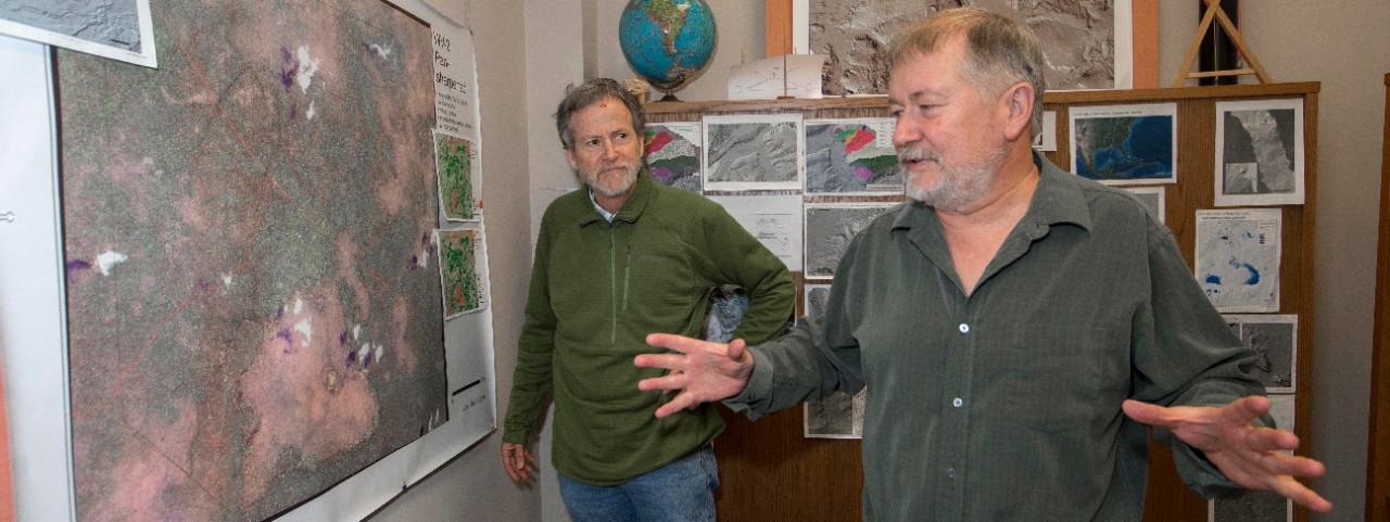
Featured image at top: University of Cincinnati geography professor Nicholas Dunning, right, and assistant professor Christopher Carr talk about a satellite image where they found evidence of ancient Maya agriculture. Photo/Joseph Fuqua II/UC Creative Services

University of Cincinnati geography professor Nicholas Dunning, center, takes a sediment core at the archaeological site of an ancient Maya reservoir in Yaxnohcah, Mexico. Photo/Nicholas Dunning
Next Lives Here
The University of Cincinnati is classified as a Research 1 institution by the Carnegie Commission and is ranked in the National Science Foundation's Top-35 public research universities. UC's graduate students and faculty investigate problems and innovate solutions with real-world impact. Next Lives Here.
Related Stories
Ticks that survive pesticides can withstand colder winters
July 17, 2026
Ticks that survive less-than-lethal doses of pesticide are able to withstand dangerous cold, which could help them expand their range farther north, according to researchers at the University of Cincinnati and the U.S. Department of Agriculture.
Why does it feel like so many Cincinnati restaurants close?
July 17, 2026
WLWT and the Cincinnati Enquirer cited UC research in reports on recent restaurant closures in the city.
UC has connection to city of legend behind 'Odyssey'
July 17, 2026
WVXU highlights a big connection between Cincinnati and director Christopher Nolan's new movie "The Odyssey." UC Classics Professor Carl Blegen led excavations at Troy in the 1930s. UC has a vast collection of photos and other records from the ambitious archaeological project.